
Reading Time: 6 minutes
This article provides actions to take when walking or driving in an area where there is a high risk of bushfire.
Check weather forecast, fire danger rating, emergency apps
Check the weather forecast, the Fire Danger Rating and State Emergency App(s) regularly, at least daily. If mobile phone coverage is patchy or non existent, arrange to make regular contact via a satellite device with the Trip Contact, who can monitor information during higher bushfire risk or extreme weather.
Check for smoke
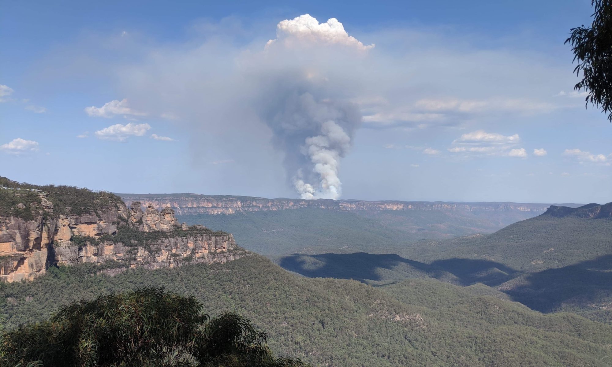
Check for smoke – from nearby to distant.
-
- Smoke is the first indicator of a bushfire, but there are many other causes of smoke, such as controlled fuel reduction burns in the autumn or spring, activity on private land, etc..
- Smoke can appear as a rising column, or it may be a local or general haze, perhaps quite thick and unpleasant.
- Smoke haze may have come from distant fires or fuel reduction burns, and its presence may be included in the weather forecast.
- Many bushfires are small and are contained by the Fire Services.
Smoke is a common sight in the Australian landscape, and does not always indicate an imminent or potential bushfire threat.
Do not be complacent. A bushfire can grow in size and move very quickly, when conditions are dry, hot and windy. Hence the importance of monitoring the Fire Danger Rating and weather forecast.
Dry Lightning
Dry lightning is a common cause of bushfires. Lightning strikes from a thunderstorm that has little or no rain can ignite vegetation and start many small bushfires. Bushwalkers should be especially alert if a thunderstorm occurs and is followed by hot, dry, windy weather.
Is the smoke a threat?
If smoke is sighted that could be a threat, STOP.
Collect information:
- Estimate the location of the smoke
- *Emergency information, advice and warnings current for the area
- Current weather conditions
- Weather forecast. Wind strength and direction is particularly important, as it will indicate the more likely direction and spread of the fire
- Current Fire Danger Rating
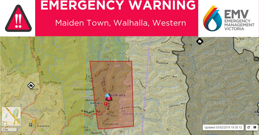
*Emergency Warnings
- Call 000 immediately if a possible bushfire is observed that is not identified on the Emergency app.
- When a fire is known to emergency services, emergency information, advice and warnings can change frequently, hence the need to check regularly. Advice, while very important and invaluable, may lag events on the ground.
- Emergency advice may indicate the fire has been contained; a great reassurance to a bushwalking group. On the other hand, a fire that is not yet contained will be a concern.
- Emergency advice and warnings will be for a wider area and will not necessarily relate to the circumstances of a bushwalking group in a specific location. For example, advice to “Evacuate now”, may be impossible for a bushwalking group on foot and away from their vehicles or a road.
Consider local circumstances:
- How close is the fire?
- What direction is it moving?
- Vegetation: Is the fire in forest, scrub or grassland? Fires can move very quickly across grassland.
- Terrain: Will the fire be travelling uphill? Fires burn very quickly uphill.
- Group location: how much vegetation, tree cover and ground litter is there? (Fuel for the fire.)
- Other local factors, e.g. cliff lines or escarpments that limit options.
Taking into account the above information, including Emergency advice and warnings, study the map to decide on the best course of action.
TAKE ACTION – get to a safe location
The first and enticing option may be to return to the group’s cars and leave the area. However, a realistic assessment is required. It may be very dangerous to attempt to do so.
Issues can include:
- Cars may be in a direction more likely to be threatened by the fire
- Walking route may be along a narrow track through thick scrub
- Cars may be too far away
- Exit route may be a lengthy drive along narrow tracks through heavy vegetation or thick smoke
- Cars provide a very poor refuge from a bushfire
If leaving the area is not an option, identify the safest location available that offers the best shelter and protection, and can be reached in the time available by a safe route.
In a remote area
- Any large area with minimal or no vegetation, such as a rocky plain, a beach, sand dunes, a lake or river with an open shoreline.
In less remote areas, in addition to the above:
- A road where emergency services are likely to be encountered. Take great care if on a road or track, as vehicles will not expect people on foot and heavy smoke can greatly reduce visibility
- Ploughed paddocks or green crops
- Buildings, e.g. a resort, National Parks buildings, village, town or farm
- Large car park or camping ground
Look after the group
In the circumstances of a bushfire threatening a walking group:
- Reassure, support and assist group members
- Ensure the group knows and understands the plan
- Monitor the group; some will be more frightened than others
- Keep the group together
- Ensure all group members have some drinking water
- Be alert for heat exhaustion or heat stroke
- Consider a buddy system. Do not let anyone shelter alone.
If there is no mobile phone coverage
- Some remote areas may not have mobile phone coverage, so there will be no access to the Emergency Warnings.
- For these trips, carry a satellite communications device to provide a means for the Trip Contact to relay emergency warnings.
- In the event of a larger bushfire, the mobile phone network can become overloaded, or fail due to mobile towers being burnt.
Encountering smoke or fire when driving
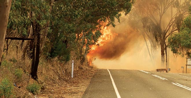
Driving through thick smoke or when there is burning vegetation on the roadside is extremely dangerous. It has been the cause of many fatalities in Australia. The fire itself is a grave threat, and there is also a very high risk of collision with fallen trees or other vehicles, or running off the road.
If smoke or a burning vegetation is ahead:
- Turn on the headlights and hazard lights
- Pull over to the side of the road
- Check emergency advice and warnings for the area
- Assess the situation
- Check the map
Leave the area
Emergency Warning may advise to leave the area and state which roads to use and which roads are closed.
Only attempt to leave the area if there is a safe and practical route to safety from your location.
If there are several cars in the group, ensure that all drivers have the same information, and understand the plan and the route to be followed.
When leaving the area, always follow directions and advice of Police and Emergency Services personnel. Obey Road Closed signs.
Too late to leave
The Emergency Warning may state that it is too late to leave the area, or that leaving the area may not be possible from the particular location.
Seek a safe, accessible location where the bushfire may be less intense (less vegetation), and that offers protection from the radiant heat:
- A beach, river or lakeside
- Ploughed paddocks or a green crop
- Buildings, e.g. a resort, National Parks buildings, village, town or farm
- Large car park or camping ground
Driving through smoke
If the smoke is not too thick, there is some visibility and having consulted the map to determine a safe exit route:
- Close car windows and vents
- Put headlights on low beam
- Drive very slowly
- Watch out for fire-fighting vehicles, other vehicles, pedestrians or animals on the road
- Watch out for fallen trees across the road
If there is more than one car in the group, do not drive in a convoy. Drive through the smoke one at a time. Once safely clear of smoke, advise the next car by mobile phone.
A vehicle that will be driven in rural areas during the fire season should be well prepared. Critical items are drinking water, woolen blankets and maps.
See also
References and acknowledgements
State Rural or Country Fire Service websites have a great deal of informative educational and explanatory material on bushfire safety.
Source material used in this article was accessed in April 2020.